🚢 The ocean is becoming the world’s most contested AI battleground. From autonomous cargo vessels navigating international waters to AI systems detecting sanctioned “ghost ships” hiding from satellite surveillance, this guide covers how artificial intelligence is reshaping maritime security, operations, and global trade in 2026.
Last Updated: May 23, 2026
Roughly 90% of everything the world buys travels by sea. That single statistic explains why the maritime industry — historically one of the slowest sectors to embrace new technology — is now under enormous pressure to modernize fast. Fuel costs, geopolitical disruptions, port congestion, and the global push for emissions reduction have converged at the same moment that AI has become genuinely capable of handling the complexity of ocean-scale operations. The result is a transformation that is no longer theoretical. AI in maritime shipping has moved from pilot programs to operational deployment across the world’s largest fleets, busiest ports, and most sensitive trade routes.
The scale of the shift is reflected in the market figures. According to Lloyd’s Register, the maritime AI market reached $4.13 billion in 2024 and is growing at a 23% CAGR — one of the fastest adoption curves of any industrial sector. In that same year, 420 organizations adopted AI technologies in maritime, up from 276 in 2023. Separately, Grand View Research projects the market will expand at a 40.6% CAGR through 2030 as autonomous vessels, predictive maintenance platforms, and AI-powered port systems move from trials to standard operating practice. This is not incremental improvement — it is structural change.
This guide covers the full landscape of AI’s role in maritime and shipping in 2026: how it is optimizing routes and cutting fuel costs, how autonomous ships are progressing from concept to commercial trials, how AI is being used to detect dark vessels and enforce international sanctions, and what the regulatory framework governing all of it looks like. Whether you are a shipping executive, a supply chain professional, a port operator, or simply someone trying to understand how global trade actually works today, this article gives you the complete picture — with the current data, real-world examples, and practical context you need.
📖 New to AI terminology? Visit the AI Buzz AI Glossary — 65+ essential AI terms explained in plain English, each linking to a full in-depth guide.
1. 📊 The State of AI in Maritime Shipping (2026)
The maritime industry is experiencing an AI adoption surge unlike anything in its recent history. The numbers tell a compelling story: Grand View Research estimates the global maritime AI market at $4.32 billion in 2024, projecting growth at a 40.6% CAGR through 2030. A separate forecast from Research and Markets values the market at $6.67 billion in 2026, growing to $8.62 billion by 2030. The variation in figures reflects different scope definitions — some include only onboard AI systems, others capture the full ecosystem of port management, fleet analytics, and intelligence platforms — but every credible estimate points in the same direction: rapid, sustained growth driven by genuine operational need.
What is driving this growth? Three forces are converging simultaneously. First, the International Maritime Organization’s tightening emissions standards — including the Carbon Intensity Indicator (CII) ratings that now require measurable annual reductions — are forcing shipping companies to find fuel efficiency gains that manual operations simply cannot achieve. AI-powered voyage optimization delivers those gains in a verifiable, auditable way. Second, the explosion of onboard sensor data from modern vessels has created a data abundance that only AI can convert into actionable intelligence — from predictive maintenance signals buried in vibration and temperature readings to real-time weather routing adjustments that would take a human navigator hours to calculate. Third, the geopolitical environment of 2025–2026, marked by sanctions evasion, dark fleet activity, and contested trade routes, has created urgent demand for AI-powered maritime domain awareness that can see what traditional AIS-based monitoring cannot.
The adoption pattern is also revealing. According to Lloyd’s Register data, 420 organizations adopted maritime AI technologies in 2024 — a 52% increase over 2023. The growth is not confined to the largest shipping conglomerates. Mid-sized operators, port authorities, and maritime insurers are all deploying AI tools, often through AI-as-a-Service (AIaaS) models that eliminate the need for heavy infrastructure investment upfront. Veson Nautical, one of the leading maritime commercial management platforms, has moved toward embedding purpose-built AI directly into commercial workflows — a recognition that generic large language models applied over maritime systems without domain context create more risk than value in an industry built on complex contracts and regulatory compliance.
Key Market Drivers in 2026
Several specific pressures are accelerating AI adoption across the maritime sector this year. The EU’s FuelEU Maritime regulation and Emissions Trading Scheme (ETS), which took full effect in January 2026, now require vessels calling at European ports to pay for their carbon emissions — creating a direct financial incentive to optimize every voyage. The International Maritime Organization’s MASS Code (Maritime Autonomous Surface Ships Code), finalizing in 2026 before a target transition to mandatory status by 2032, is creating the regulatory clarity that operators need to invest in autonomous vessel programs with confidence. And the expansion of sanctions enforcement — with over 1,000 vessels sanctioned by Q3 of 2025 alone — has made AI-powered maritime intelligence a compliance necessity rather than a competitive advantage.
Who Is Deploying Maritime AI Today
The deployment landscape spans every segment of the industry. Shipping companies including Mitsui OSK Lines (MOL), Maersk, and Evergreen are deploying predictive maintenance and voyage optimization platforms. Port authorities in Singapore, Rotterdam, and Hamburg are using AI for berth allocation, container tracking, and traffic management. Naval organizations and coast guards — including the U.S. Navy, NATO member states, and South Korea’s Ministry of Oceans and Fisheries — are deploying AI-powered unmanned surface vehicles and surveillance platforms. Maritime insurers, including those operating within the Lloyd’s of London market, are using AI to assess hull risk, flag anomalous vessel behavior, and streamline claims processing. The industry-wide scope of adoption means that AI is no longer a differentiator for early movers — it is rapidly becoming the operational baseline.
2. 🛳️ AI-Powered Voyage Optimization and Fuel Efficiency
Fuel represents 50–60% of a commercial vessel’s operating costs. For a Very Large Crude Carrier (VLCC) operating on a 30-day transoceanic voyage, a 5% improvement in fuel efficiency translates directly into hundreds of thousands of dollars in savings per trip. This is where AI has delivered the most immediate and measurable return on investment for maritime operators — and why voyage optimization was the first AI application to achieve widespread commercial adoption in the sector.
AI voyage optimization systems work by ingesting continuous streams of data that no human navigator could process in real time: ocean current patterns, wind speed and direction, wave height and frequency, weather forecasts updated at 15-minute intervals, port traffic and expected waiting times at the destination berth, vessel trim and load distribution, and real-time fuel consumption telemetry. Machine learning models process all of this simultaneously to recommend — or in more advanced deployments, autonomously adjust — speed, heading, and engine power settings to find the optimal balance between journey time, fuel consumption, and emissions compliance. The result is what the industry calls “slow steaming optimization” done by algorithm rather than intuition.
The results in production deployments are substantial. Mitsui OSK Lines reported a 25% reduction in unplanned maintenance downtime after deploying IBM’s Maximo AI platform, which uses vibration and temperature sensor data to flag engine issues before they escalate into failures. On the fuel side, studies across multiple operators have demonstrated that AI-optimized routing consistently delivers fuel savings of 10–15% compared to conventional navigation — a figure that compounds dramatically across a fleet of dozens or hundreds of vessels. The IMO credits AI and related digital technologies with contributing to an 8% reduction in maritime CO₂ emissions in recent years, a figure that will need to accelerate significantly as CII enforcement tightens through 2026 and beyond.
Weather Routing and Real-Time Adjustments
One of the most sophisticated capabilities in AI voyage optimization is real-time weather routing — the ability to dynamically reroute a vessel mid-voyage in response to developing storm systems, unexpected current shifts, or changing port conditions at the destination. Traditional weather routing relied on pre-voyage planning using forecast data, with limited capacity for mid-voyage adjustment. AI systems, particularly those using deep learning models trained on decades of meteorological and oceanographic data, can now recompute optimal routes continuously and push updated waypoint recommendations to the bridge in near real time.
This capability matters not only for fuel savings but for safety. Human error is cited as the cause of 75–96% of all maritime accidents, depending on the study. AI navigation assistance systems — which integrate radar, GPS, AIS data, and computer vision to provide collision avoidance alerts and course correction recommendations — reduce the cognitive load on bridge crews during high-complexity situations. AI-powered navigation systems from Kongsberg, Rolls-Royce, and HD Hyundai’s Avikus subsidiary are now installed on vessels operating in commercial service, with Avikus’s HiNAS Control system forming part of the newly established MIT Maritime Consortium launched in March 2025 to set international standards for autonomous navigation.
Digital Twins: Testing Before Deploying
A growing number of shipping companies and shipyards are using digital twins — virtual replicas of physical vessels — to test operational scenarios and design modifications before making real-world changes. Lloyd’s Register uses digital twin technology to help shipping companies simulate emergency scenarios and test hull designs under stress conditions. In February 2025, Siemens Digital Industries Software partnered with Compute Maritime to integrate the NeuralShipper AI platform with Siemens’ Simcenter STAR-CCM+ computational fluid dynamics software — a collaboration that uses generative AI and advanced simulation to accelerate vessel design and optimize fuel performance before a ship is even built. Digital twins are also used to model the impact of alternative fuel types — including LNG, methanol, and ammonia — on engine performance and emissions profiles, supporting the fuel transition decisions that operators need to make now for vessels that will be in service for 20–30 years.
3. 🤖 Autonomous Ships: From Concept to Commercial Trials
Autonomous shipping has moved from a speculative future to an active present. The Yara Birkeland, the world’s first fully electric autonomous container ship, began commercial operations along Norway’s coast in 2023, shuttling fertilizer between ports with AI navigation systems and minimal crew supervision. China launched the Xin Hong Zhuan smart research vessel in June 2025, designed to showcase domestic autonomous navigation capabilities. Singapore’s Maritime and Port Authority and Japan’s NYK Line launched joint autonomous ship trials in actual port conditions in June 2025 — testing how Maritime Autonomous Surface Ships (MASS) interact with live vessel traffic in one of the world’s busiest harbors. These are not demonstrations. They are operational trials producing real data about what works and what does not in the complex, unpredictable environment of commercial shipping.
The development of autonomous vessel technology follows a tiered framework similar to the levels used for self-driving cars. Level 1 systems provide decision support to human crews while maintaining full human control. Level 2 automation handles specific functions — navigation or engine management — while humans monitor all systems. Level 3 systems operate independently with human oversight available remotely. Level 4 systems operate fully autonomously, with shore-based control centers available for intervention but not required for routine operation. Most commercial deployments in 2026 are operating at Levels 1–2, with Level 3 trials underway on specific routes. Full Level 4 commercial operation at scale remains a 2030s prospect, contingent on the finalization and widespread adoption of the IMO MASS Code.
The regulatory timeline is now clearer than it has ever been. The IMO finalized nearly all chapters of the MASS Code draft during its 110th session in June 2025. Final adoption is expected in 2026, with a non-mandatory framework initially, transitioning toward mandatory international standards by 2032. South Korea’s Ministry of Oceans and Fisheries introduced new regulatory guidelines in August 2025 allowing partial autonomy in domestic waters for commercial and passenger vessels under 300 gross tonnes — one of the first national frameworks to create a clear legal pathway for autonomous commercial trials. The regulatory momentum is accelerating, and operators investing in autonomous technology today are positioning themselves to lead when the mandatory framework takes effect.
Defense Applications: Unmanned Surface Vehicles
The defense and naval sector is driving some of the most aggressive autonomous vessel development currently underway. In January 2026, Hanwha Defense USA and HavocAI entered a joint agreement to develop 200-foot autonomous surface vessels (ASVs), with production planned at the Philadelphia Shipyard to meet surging demand for large-scale unmanned naval platforms. Saronic Technologies announced a $300 million investment in December 2025 to expand its Louisiana shipyard with dedicated production lines for large autonomous vessels. NATO conducted live trials of unmanned surface vessels under its experimental “Task Force X” in the Baltic Sea in June 2025. Taiwan conducted its first large-scale unmanned surface vessel demonstration in mid-June 2025 as part of its maritime defense posture development.
In March 2025, Saildrone and Palantir Technologies announced a strategic partnership integrating Palantir’s AI cloud infrastructure with Saildrone’s autonomous surface vehicles — a combination designed to advance AI-powered maritime intelligence for both defense and commercial applications. These defense investments are significant for the commercial sector because technologies developed for military autonomous vessels — including high-endurance propulsion systems, advanced sensor fusion, and resilient communication architectures — consistently migrate into commercial shipping applications within 5–10 years of initial military deployment.
The Human Element: Shore Control Centers
A common misconception about autonomous shipping is that it eliminates human involvement entirely. The practical reality in 2026 is more nuanced. Even the most advanced autonomous vessels operating today maintain connections to shore-based control centers where human operators monitor multiple vessels simultaneously and can intervene when onboard AI systems encounter conditions outside their operational parameters. These remote operation centers are themselves AI-assisted — using dashboards that aggregate sensor feeds, navigation data, weather overlays, and traffic information across entire fleets to help human supervisors identify which vessels need attention at any given moment. The model is less “no human” and more “the right human, in the right place, with full situational awareness” — a pattern consistent with the human-in-the-loop AI governance framework that enterprise AI deployments across every sector are converging toward.
🏭 Exploring AI in your industry? Browse the AI Buzz Industry Guide — 35+ in-depth sector guides covering how AI is transforming healthcare, finance, HR, legal, retail, manufacturing, and more.
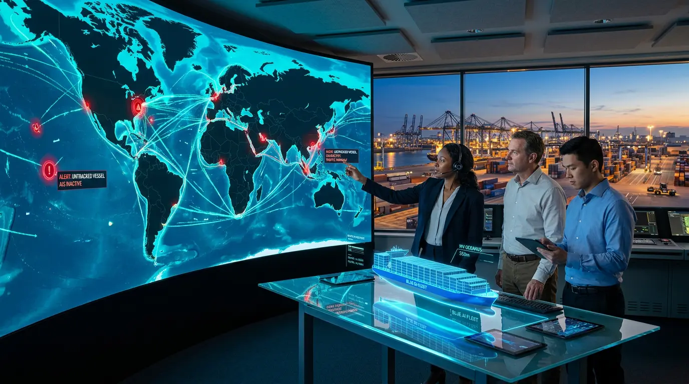
4. 🕵️ Dark Vessels, AIS Spoofing, and AI-Powered Maritime Domain Awareness
If AI’s role in voyage optimization and autonomous shipping represents the efficiency dimension of maritime transformation, its role in dark vessel detection and maritime domain awareness represents the security dimension — and this is where the stakes are highest. The global shadow fleet, also known as the dark fleet, refers to tankers and support vessels that use deceptive practices to move sanctioned commodities while concealing their identity, location, or ownership. This ecosystem expanded rapidly following the start of the Russia-Ukraine war and subsequent Western sanctions on Russian oil exports. By Q3 of 2025, Windward’s maritime intelligence data showed the dark fleet had reached over 1,900 active tankers, supported by more than 1,200 gray fleet vessels — ships that exhibit Russia-linked risk indicators without being formally sanctioned.
The core deception mechanism is AIS manipulation. The Automatic Identification System was designed as a collision-avoidance tool — not a surveillance system. Vessels transmit their position, identity, speed, and heading via AIS transponders, and that data feeds the tracking platforms used by port authorities, coast guards, insurers, and logistics companies worldwide. The problem is that AIS is trivially easy to manipulate. A vessel can simply disable its transponder to go “dark.” It can spoof its location — broadcasting false GPS coordinates while physically being somewhere else entirely. It can clone another vessel’s MMSI identity number. It can conduct ship-to-ship (STS) transfers of sanctioned cargo in international waters between two dark vessels, then reappear with clean paperwork hundreds of miles away. AIS spoofing incidents increased over 200% between 2022 and 2025, according to Planet Labs data — a direct reflection of how dramatically sanctions enforcement has intensified and how aggressively evasion tactics have evolved in response.
The scale of the problem in 2025 was extraordinary. Windward’s data showed that GPS jamming incidents affected more than 24,000 vessels across Q1–Q3 of 2025, with AIS “jumps” averaging 6,300 km — meaning vessels were appearing to teleport thousands of kilometers on tracking systems. False flagging surged from 223 to more than 370 vessels within the year. These are not marginal anomalies — they represent a coordinated, systematic effort by state-adjacent networks to exploit the limitations of AIS-based monitoring at industrial scale.
How AI Detects What AIS Cannot
The response to this challenge has driven one of the most technically sophisticated AI applications in any industry: multi-source maritime domain awareness. The fundamental insight is that AIS data alone is insufficient — but AIS data fused with satellite imagery, synthetic aperture radar (SAR), radiofrequency (RF) signal monitoring, and behavioral analytics creates a picture that is extremely difficult to falsify. AI systems built for this purpose, from companies including Windward, Spire Global, Planet Labs, and Kpler, ingest all of these data streams simultaneously and use machine learning models to identify behavioral anomalies that indicate deceptive activity.
Planet Labs’ Maritime Domain Awareness solution, which demonstrated vessel detections in the Strait of Malacca in January 2026, uses AI to automatically detect and categorize vessels in near-daily satellite imagery — regardless of whether those vessels are transmitting AIS signals. The system can identify a vessel physically present at a location even when its transponder claims to be somewhere else. Turqoa’s dark vessel detection platform cross-references AIS gaps, satellite optical imagery, and historical behavioral patterns to identify ships that have disabled transponders for operationally suspicious reasons — distinguishing genuine equipment failures from deliberate evasion. The distinction matters: a tanker that disables AIS while transiting the Gulf of Oman and then reappears near a known STS hotspot in the Red Sea is exhibiting a pattern consistent with sanctions evasion; a container ship that loses AIS signal near a known cellular dead zone is not.
Real-World Enforcement: The Tanker Skipper Case
The practical impact of AI-powered maritime intelligence on sanctions enforcement was demonstrated in December 2025, when U.S. Coast Guard and special operations forces seized the oil tanker Skipper in the Caribbean following AI-assisted detection of AIS spoofing. The vessel’s transponder was broadcasting coordinates placing it near Guyana and Suriname. Maritime intelligence firms including Kpler and TankerTrackers.com, using satellite imagery and AI analytics, physically located the ship loading sanctioned Venezuelan crude at José terminal — hundreds of miles from its declared position. The operation, launched from the USS Gerald R. Ford aircraft carrier, represented the direct operational conversion of AI maritime intelligence into a law enforcement action. It is a template that U.S. and allied forces are actively developing into repeatable enforcement capability for the broader dark fleet problem.
The intelligence gap AI closes: Traditional maritime monitoring asks “where is this vessel?” AI-powered domain awareness asks “is this vessel’s behavior consistent with its declared identity, route, and cargo?” — a fundamentally different and far more powerful question.
Sanctions Compliance for Commercial Operators
Dark vessel detection is not only a government and naval concern. Commercial operators — shipping companies, cargo insurers, commodity traders, and port operators — face significant legal and financial exposure from unknowingly facilitating sanctioned trade. The U.S. Office of Foreign Assets Control (OFAC) has been explicit that “unknowing” facilitation of sanctions violations does not provide legal immunity when due diligence tools are available. This has driven adoption of AI-powered vessel vetting platforms across the commercial maritime ecosystem. Platforms like Windward’s Maritime AI™ provide dynamic risk scores for individual vessels that update in real time as behavioral signals change — replacing static watchlists that were obsolete by design in a dark fleet environment where vessel identities change faster than lists can be updated.
5. 🏗️ AI in Smart Ports and Port Operations
Ports are the chokepoints of global trade. A container ship carrying $200 million worth of goods generates zero revenue while waiting at anchor outside a congested port. Port delays cascade through supply chains in ways that are disproportionate to their duration — a 12-hour delay at one port can trigger days of disruption at downstream facilities that were synchronized to the original arrival schedule. Reducing port congestion and improving berth utilization is therefore one of the highest-value applications of AI in the entire maritime ecosystem, and the world’s leading ports are investing accordingly.
AI port management systems address the optimization problem from multiple angles simultaneously. Berth allocation algorithms use predictive models that incorporate vessel arrival forecasts, tide tables, cargo type and volume, crane availability, yard capacity, and labour scheduling to assign berths dynamically rather than through manual dispatcher decisions made hours or days in advance. Container tracking systems using computer vision — cameras mounted across port infrastructure that can read container identification numbers and track physical location in real time — replace manual scanning processes that are both slower and more error-prone. Traffic management systems for port roads, rail connections, and water approaches use AI to sequence vehicle and vessel movements to minimize waiting time and maximize throughput.
The Port of Singapore, consistently ranked the world’s busiest transshipment hub, has been deploying AI across multiple operational layers including predictive berthing, automated crane scheduling, and vessel traffic management in its approaches. Rotterdam’s Port Community System integrates data from hundreds of stakeholders — shipping lines, terminals, customs, road and rail carriers — into an AI-optimized logistics platform that can identify and resolve coordination failures before they become delays. These smart port deployments are not simply replacing manual tasks with automation — they are enabling optimization across the entire port ecosystem that was previously impossible because no human coordinator could hold all of the relevant variables in mind simultaneously.
Predictive Maintenance in Port Infrastructure
AI predictive maintenance applications in maritime extend beyond vessels to port infrastructure itself. Cranes, conveyor systems, locks, gates, and mooring equipment are all subject to wear and failure — and unplanned equipment failure in a port environment has multiplier effects on the hundreds of vessels and thousands of containers in the affected area. IoT sensors embedded in critical port infrastructure feed data to AI maintenance platforms that identify wear signatures before they lead to breakdowns, allowing maintenance to be scheduled during planned low-traffic windows rather than emergency repair during peak operations. This is the same predictive maintenance paradigm deployed on vessels — detecting anomalies in vibration, temperature, current draw, and acoustic signatures — applied to the fixed infrastructure that processes those vessels at each end of their journeys.
6. 🌿 AI, Decarbonization, and the Emissions Compliance Imperative
The maritime industry accounts for approximately 2.5% of global greenhouse gas emissions — a figure that sounds modest until you convert it to absolute terms: roughly 1 billion tonnes of CO₂ equivalent per year. The IMO has set a target of net-zero GHG emissions from international shipping by or around 2050, with interim targets requiring a 40% carbon intensity reduction by 2030 compared to 2008 levels. Meeting these targets while maintaining the volume of global trade — which is projected to continue growing — requires efficiency improvements that manual operations cannot deliver. AI is central to how the industry intends to close that gap.
The most direct contribution is voyage optimization: AI-optimized routing, speed management, and trim optimization collectively reduce fuel consumption by 10–15% across a fleet, with some operators reporting higher savings on specific route types. But AI’s contribution to decarbonization extends beyond operational optimization. AI simulation tools are accelerating the design of next-generation vessels with improved hydrodynamic profiles — the Siemens-Compute Maritime NeuralShipper collaboration mentioned earlier being a prime example. AI-powered monitoring systems are enabling real-time emissions tracking and CII compliance management, giving operators visibility into where they stand relative to their annual targets and the ability to intervene before they fall into a compliance penalty. And AI is being used to optimize the transition to alternative fuels — modeling the performance, cost, and emissions implications of LNG, methanol, and ammonia across different route types and regulatory environments.
The 2026 regulatory reality: The EU ETS now applies to maritime. FuelEU Maritime is in force. CII ratings are being enforced with commercial consequences. For any vessel calling at a European port, AI-powered emissions monitoring is no longer optional — it is the only practical way to manage compliance across a fleet at scale.
The regulatory environment in 2026 is more demanding than at any point in the industry’s history. The EU’s Emissions Trading Scheme for maritime, which took full effect in January 2026, requires shipping companies to purchase carbon allowances for emissions from voyages to and from European ports — a direct financial cost that scales with emissions volume and incentivizes every efficiency gain AI can deliver. The FuelEU Maritime regulation adds a parallel requirement for progressively lower carbon intensity in the fuels used, penalizing operators who cannot demonstrate compliance. For shipping companies operating in European trade lanes, AI-powered emissions management has moved from a strategic initiative to a compliance necessity in a single regulatory cycle.
7. ⚠️ Risks, Cybersecurity, and the Governance Challenge
Every AI capability deployed in maritime operations creates a corresponding attack surface. An autonomous vessel whose navigation system can be compromised via satellite uplink is a ship that can be steered off course, grounded on a reef, or used as a weapon in a congested port. An AI-powered port management system whose berth allocation database can be poisoned with false data is a chokepoint that can be disrupted without a single physical attacker setting foot on the premises. The cybersecurity risks of maritime AI are not hypothetical — they are documented, active, and growing in sophistication as the value of maritime AI deployments increases.
GPS jamming and spoofing — which affected over 24,000 commercial vessels in 2025 — is both a dark fleet tactic and a cyberwarfare tool. The Baltic Sea, Arabian Gulf, and Eastern Mediterranean emerged as persistent GPS jamming hotspots in 2025, where AIS reporting diverged systematically from real-world vessel positions. These disruptions affect commercial navigation safety, insurance validity, and supply chain visibility simultaneously. New spoofing hotspots in these regions represent strategic vulnerabilities for the global supply chains that transit them. Operators relying solely on GPS and AIS for navigational verification — rather than multi-sensor fusion — are exposed to manipulation that they may not even recognize as manipulation in real time.
The cybersecurity challenge is compounded by the operational technology (OT) environment aboard modern vessels. Ships carry a complex mix of legacy systems — some decades old, running proprietary software with no security patching history — alongside modern AI navigation systems, satellite communications, and IoT sensor networks. The integration of these systems creates attack surfaces that are difficult to inventory, harder to patch, and nearly impossible to monitor continuously without dedicated maritime cybersecurity tools. The IMO’s Resolution MSC-FAL.1/Circ.3 requires shipping companies to incorporate cyber risk management into their Safety Management Systems — but compliance verification is inconsistent, and the threat landscape is evolving far faster than the regulatory response. Organizations looking for a framework to assess and manage these risks should examine the NIST Cyber AI Profile (NIST IR 8596), which provides a structured approach to securing AI systems that is directly applicable to the maritime operational technology environment.
AI Supply Chain Integrity and Vendor Risk
Maritime operators deploying AI systems from third-party vendors face the same AI supply chain risks that affect enterprise AI adoption across every sector — but with consequences that are more physically immediate. An AI navigation system that fails unexpectedly at sea does not just lose data; it puts vessel, crew, and cargo at risk. Vendor due diligence for maritime AI procurement must include evaluation of the training data used to build the model, the failure modes documented by the vendor, the update and patching cadence, and the contractual accountability framework when the system produces an error that contributes to an incident. The AI vendor due diligence checklist framework provides a structured approach to these evaluations that maritime procurement teams can adapt to their specific operational context.
The MASS Code and Emerging Regulatory Framework
The regulatory framework governing AI in maritime is developing across multiple simultaneous tracks. The IMO MASS Code addresses the safety and operational standards for autonomous vessels specifically. IMO Resolution MSC-FAL.1/Circ.3 addresses cyber risk management for all vessels. The EU ETS and FuelEU Maritime regulations create emissions compliance obligations that AI systems must support. The Ship Recycling Rules under the Hong Kong Convention, entering into force in 2026, introduce new end-of-life standards with data and documentation requirements that AI asset management platforms will need to support. For operators navigating this multi-regulatory environment, the practical implication is that AI governance in maritime is not a single compliance exercise — it is an ongoing program that must track developments across IMO, EU, national maritime administrations, and flag state requirements simultaneously.
| Regulatory Framework | Effective Date | What It Requires | AI Implication |
|---|---|---|---|
| EU Emissions Trading Scheme (Maritime) | January 2026 | Carbon allowance purchases for EU port voyages | AI emissions monitoring and CII optimization platforms |
| FuelEU Maritime | January 2026 | Progressive carbon intensity reduction in marine fuels | AI fuel management and alternative fuel transition modeling |
| IMO MASS Code | 2026 (non-mandatory); 2032 (mandatory target) | Safety framework for Maritime Autonomous Surface Ships | Autonomous vessel certification and operational standards |
| IMO Cyber Risk Resolution (MSC-FAL.1/Circ.3) | Active (since 2021, enforcement expanding) | Cyber risk management in Safety Management Systems | AI system security documentation and incident response |
| IMO CII Ratings | Active, tightening annually | Annual carbon intensity reductions (minimum 2% per year) | AI voyage optimization and fuel efficiency tracking |
| Hong Kong Ship Recycling Convention | 2026 | International standards for environmentally sound ship recycling | AI asset management and documentation platforms |
8. 🏁 Conclusion: Navigating the AI-Powered Future of Shipping
The maritime industry’s AI transformation is no longer a story about what might be possible — it is a story about what is already happening, at scale, across the most consequential logistics network on earth. Voyage optimization is saving fuel and cutting emissions on ships operating commercial routes today. Predictive maintenance platforms are preventing engine failures before they happen on vessels carrying billions of dollars in cargo. Dark vessel detection systems are converting satellite imagery and behavioral analytics into sanctions enforcement actions. Autonomous ships are conducting port trials in Singapore, commercial operations in Norway, and military exercises in the Baltic. The question for maritime operators in 2026 is not whether to engage with AI — it is how to do so with the rigor, security awareness, and governance discipline that operating in a high-stakes physical environment demands.
The organizations that will lead the next decade of maritime shipping are the ones building their AI capabilities on a foundation of data quality, purpose-built tools, and clear accountability frameworks — not those applying generic AI over legacy systems and hoping for the best. Veson Nautical’s chief commercial officer put it plainly: maritime is a nuanced field built on complex contracts and regulatory compliance, and it requires AI capabilities designed specifically for its standards. That insight applies equally to autonomous navigation, emissions management, sanctions compliance, and cybersecurity. The sea does not forgive shortcuts. The AI systems operating on it, around it, and in service of the trade that crosses it every day must be held to the same standard.
📌 Key Takeaways
| Key Takeaway | |
|---|---|
| ✅ | The global maritime AI market reached $4.13 billion in 2024 and is growing at a 23% CAGR, with 420 organizations adopting maritime AI in 2024 alone — a 52% increase over 2023. |
| ✅ | AI voyage optimization delivers consistent fuel savings of 10–15% per vessel, with compounding fleet-wide impact — Mitsui OSK Lines reported 25% reduction in unplanned downtime after deploying IBM’s Maximo AI platform. |
| ✅ | Autonomous commercial shipping has moved from concept to operational trials: the Yara Birkeland is in commercial service, Singapore and Japan are running live port trials, and the IMO MASS Code is finalizing in 2026. |
| ✅ | AIS spoofing incidents increased over 200% between 2022 and 2025; GPS jamming affected more than 24,000 vessels in 2025 alone — making multi-sensor AI fusion the only reliable approach to maritime domain awareness. |
| ✅ | The dark fleet reached over 1,900 active tankers by Q3 2025, with more than 1,000 vessels sanctioned — demonstrating that AI-powered sanctions compliance is now a commercial necessity, not just a government concern. |
| ✅ | The EU ETS (maritime) and FuelEU Maritime regulations took full effect in January 2026, making AI-powered emissions monitoring and CII compliance management legally necessary for any vessel calling at European ports. |
| ✅ | Maritime cybersecurity risks — including GPS jamming hotspots in the Baltic Sea, Arabian Gulf, and Eastern Mediterranean — require multi-sensor fusion and AI behavioral analytics, not AIS-only monitoring. |
| ✅ | Generic AI applied over legacy maritime systems without domain-specific design creates compliance and operational risk — purpose-built maritime AI with verified data, human oversight, and clear accountability frameworks is the correct standard. |
🔗 Related Articles
- 📖 AI in Supply Chains and Logistics: How AI Improves Demand Forecasting, Inventory, and Delivery
- 📖 AI in Defense & Military: Autonomous Systems, Strategic Intelligence, and the Ethics of the Digital Front Line
- 📖 AI Geopolitics & Global Sanctions: Protecting Your Supply Chain from Software Blocks
- 📖 AI in Logistics: How Companies Are Using AI to Optimise Routes, Manage Fleets, and Run Smarter Warehouses
- 📖 Human-in-the-Loop (HITL) Explained: How to Use AI Safely with Draft-Only Workflows, Approval Gates, and Clear Accountability
❓ Frequently Asked Questions: AI in Maritime & Shipping
1. Can AI completely replace human crews on commercial cargo ships today?
No — not in 2026. Most autonomous vessel deployments currently operate at Levels 1–2 autonomy, meaning AI assists or handles specific functions while humans remain in control or in oversight roles. The IMO MASS Code, finalizing in 2026, creates a framework for higher autonomy levels, with mandatory international standards targeted for 2032. Our guide to the 5 Levels of AI Autonomy explains the full progression from assisted to fully autonomous operation.
2. How does AI know a vessel is part of the dark fleet if it has turned off its AIS transponder?
AI dark vessel detection doesn’t rely on AIS alone — it fuses satellite optical imagery, synthetic aperture radar (SAR), radiofrequency signals, and behavioral pattern analysis. Even without a transponder signal, satellite imagery can physically locate a vessel and AI can compare that location to the vessel’s declared AIS history to flag suspicious gaps or implausible voyages. Our AI in geopolitics and sanctions article covers how these intelligence capabilities are applied to sanctions enforcement.
3. What is the CII rating and why does AI matter for compliance?
The Carbon Intensity Indicator (CII) is an IMO rating system that scores each vessel’s annual carbon emissions intensity and requires measurable improvement each year. Ships rated D or E face operational restrictions. AI voyage optimization platforms track CII performance in real time and model route, speed, and fuel choices against annual CII targets — making it practically impossible to manage compliance at fleet scale without them.
4. Is maritime AI adoption limited to the largest shipping conglomerates?
No. AI-as-a-Service (AIaaS) models have democratized access to advanced maritime analytics, allowing mid-sized operators, port authorities, and maritime insurers to deploy predictive maintenance, voyage optimization, and vessel vetting tools without heavy infrastructure investment. Our AI for small businesses guide covers the broader pattern of AIaaS enabling smaller organizations to access enterprise-grade AI capabilities.
5. What are the biggest cybersecurity risks specific to AI-powered ships?
The primary risks are GPS jamming and AIS spoofing (which affected 24,000+ vessels in 2025), cyberattacks targeting onboard OT systems through satellite communication links, and AI model manipulation through sensor data poisoning. The NIST Cyber AI Profile provides a structured control framework that maritime operators can adapt to assess and manage these risks within their Safety Management Systems.
📧 Get the AI Buzz Weekly Digest
Weekly AI insights, tools, and strategies — delivered every Monday. Free.


Leave a Reply